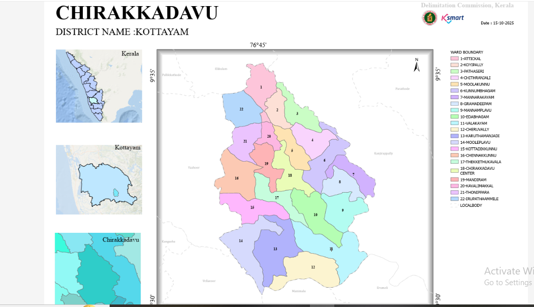
Map-2026
1. General Overview
Issuing Authority: Delimitation Commission, Kerala (Chairman: A. Shajahan).
Order Date: 15.05.2025.
Total Number of Wards: The number of seats (wards) to be filled through direct election in Chirakkadavu Grama Panchayat has been fixed at 22.
Legal Basis: This delimitation has been conducted in accordance with Section 10 of the Kerala Panchayat Raj Act, 1994.
2. Demographic Analysis
The total population of the panchayat is distributed almost equally across all 22 wards to ensure administrative parity.
Most Populous Ward: Ward 18 (Chirakkadavu Centre) – 1,796 residents.
Least Populous Ward: Ward 11 (Valakkayam) – 1,490 residents.
Average Ward Population: Maintained between 1,500 and 1,750 residents per ward.
3. Ward-wise Analysis by Region
A. Northern Region (Bordering Elikkulam Panchayat)
01 - Attikkal: Bounded by the Elikkulam Panchayat border, Pala–Ponkunnam Road, and NH 183.
02 - Koippally: Bounded by Attikkal–Manthara Road, Anuveli–Thambalakkad Road, and NH 183.
22 - Irupatham Mile: Located near the Elikkulam and Vazhoor Panchayat borders, situated between Pala–Ponkunnam Road and NH 183.
B. Eastern Region (Bordering Kanjirappally Panchayat)
03 - Pathassery: Major boundaries include the Kanjirappally Grama Panchayat border, Melaruvi Stream, and NH 183.
06 - Kunnumbhagom: Bounded by the Kanjirappally border, Melaruvi Stream, Kunnumbhagom Ground, and Chirakkadavu Temple–Karipoyka Road.
07 - Mannararkayam: Bounded by the Kanjirappally border, Kanjirappally–Manimala Road, and Chittar River.
C. Southern & South-Eastern Region (Bordering Manimala & Erumely Panchayats)
09 - Mannamplavu: Bounded by Manimala River, Kanjirappally Panchayat border, and Moonnam Mile Stream.
11 - Valakkayam: Shares borders with Manimala River, Kanjirappally & Erumely Panchayat borders, and Ponkunnam–Manimala Road.
12 - Cheruvalli: Includes Cheruvalli Temple Road, Kochi Stream, Manimala River, and Manimala & Erumely Panchayat borders.
D. Western Region (Bordering Vazhoor & Vellavoor Panchayats)
14 - Mooleplavu: Bounded on the west by Vazhoor Valiya Stream and Vazhoor Panchayat border.
15 - Kottadikunnu: Bounded by Manimala River, Vellavoor Panchayat border, and Vazhoor Valiya Stream.
16 - Chennakunnu & 21 - Thonippara: Western boundaries are defined by Vazhoor Panchayat border, Vazhoor Valiya Stream, and Poyka Stream.
E. Central & Mid-Region (Ponkunnam Town & Surroundings)
04 - Chitranjali & 05 - Moolakunnu: Major wards linked with NH 183, Ponkunnam Town, Ponkunnam–Mannamplavu Road, and Ponkunnam–Manimala Road.
18 - Chirakkadavu Centre (Largest Ward): Surrounded by Town Hall Road, Punalur–Muvattupuzha Road, and Chirakkadavu Temple Roads.
Central Interior Wards: 08 - Gramadeepam, 10 - Idabhagom, 13 - Karutha Manjadi, 17 - Thekkethukavala, 19 - Mandiram, and 20 - Kavalimakkal are inland wards demarcated by local streams and internal roads (including Punalur–Muvattupuzha Road).
4. Key Geographical Landmarks
The boundaries and wards of the panchayat have been primarily determined based on the following key features:
Major Roads: National Highway 183 (NH 183 / Old NH 220), Punalur–Muvattupuzha Road (Main Eastern Highway - SH 08), Pala–Ponkunnam Road, Ponkunnam–Manimala Road, and Anuveli–Thambalakkad Road.
Water Bodies: Manimala River (serves as the prominent southern boundary), Chittar River, Vazhoor Valiya Stream, Melaruvi Stream, Kochi Stream, and Poyka Stream.
Major Junctions / Hubs: Ponkunnam Town, Old Market (Pazhaya Chantha), Thekkethukavala, Kunnumbhagom Ground, Chirakkadavu Temple vicinity, 19th Mile, and 20th Mile junctions.
Conclusion
Through this ward delimitation, Chirakkadavu Grama Panchayat has been structured into 22 well-defined wards by effectively leveraging natural boundaries like rivers and streams alongside man-made features such as major highways and roads, ensuring smooth administrative governance.